Potton Brook - Potton Brook - Wikipedia
| Potton Brook | |
|---|---|
 Potton Park, Potton'daki Potton Brook | |
| yer | |
| Ülke | İngiltere |
| Üniter Otorite | Central Bedfordshire |
| Fiziksel özellikler | |
| Kaynak | |
| • yer | doğusu Gamlingay, Cambridgeshire, İngiltere |
| • koordinatlar | 52 ° 9′5.13″ K 0 ° 9′39.54 ″ B / 52.1514250 ° K 0.1609833 ° B |
| Ağız | |
• yer | Bedfordshire, İngiltere |
• koordinatlar | 52 ° 6′48″ K 0 ° 16′37 ″ B / 52.11333 ° K 0.27694 ° BKoordinatlar: 52 ° 6′48″ K 0 ° 16′37 ″ B / 52.11333 ° K 0.27694 ° B |
• yükseklik | 25 m (82 ft) |
| Deşarj | |
| • yer | Kumlu |
Potton Brook doğusunda yükselir Gamlingay, Cambridgeshire ve güneybatıya ve sonra güneye doğru akar Potton[1] ve John O'Gaunt Golf Kulübü ve içine Sutton, Bedfordshire. Potton Brook batı ve kuzeybatıya kıvrılır ve Ivel Nehri kuzeydoğusunda Alt Caldecote.
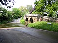
Bir yük atı köprüsü ve Bedfordshire'daki Sutton'da Potton Brook'u geç

Referanslar
- ^ "Potton-Sutton Dairesel Yürüyüşü". Ivel Kırsal projesi ve Befordshire İlçe Konseyi. Alındı 4 Ocak 2017.
| Üniter yetkililer | |
|---|---|
| Büyük yerleşim yerleri | |
| Konular | |
| Bu Bedfordshire konum makalesi bir Taslak. Wikipedia'ya şu yolla yardım edebilirsiniz: genişletmek. |
| İngiltere'deki bir nehirle ilgili bu makale bir Taslak. Wikipedia'ya şu yolla yardım edebilirsiniz: genişletmek. |